
NATIONAL WORK
MARINE SPATIAL PLANNING
The FSM, through Blue Prosperity Micronesia (BPM), is engaged in a landmark effort to create Marine Spatial Plans, which will provide national and state policymakers with the tools and knowledge they
need to make informed decisions on marine resource management.
The Marine Spatial Plans will consist of offshore and coastal planning processes:
-
The offshore Marine Spatial Plan will establish use zones and conservation areas to support FSM's goals in its offshore waters, defined as the ocean space 12-200 nautical miles from the coast.
-
The coastal Marine Spatial Plans will be developed with state governments and stakeholders and will cover the waters under state jurisdictions, from 0-12 nautical miles from the coast.
WHAT IS MARINE SPATIAL PLANNING?
Marine Spatial Planning (MSP) is a process to plan the use and development of coastal and marine areas. This is a public, stakeholder-driven and science-based process that involves mapping out different activities and uses in a specific marine area, such as shipping lanes, fishing grounds, and tourism sites, and then determining how they can best coexist and be managed sustainably.
Watch Video to Learn About Marine Spatial Planning in the FSM

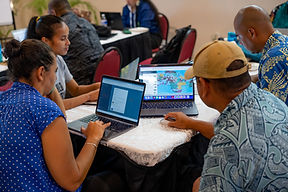
STATE-LEVEL MARINE SPATIAL PLANNING


.jpg)
WHO IS INVOLVED?
The offshore Marine Spatial Plan will establish zones and conservation areas in offshore waters, 12-200 nautical miles from the coast. It is being developed by a working group of technical experts from:
-
National Oceanic Resource Management Authority (NORMA)
-
Department of Environment, Climate Change and Emergency Management (DECEM)
-
FSM Department of Resources & Development (R&D)
-
FSM State Focal Points
-
Micronesia Conservation Trust
-
The Nature Conservancy
The coastal Marine Spatial Plan (0-12 nautical miles) processes will be developed by state government and stakeholders.


OFFSHORE MARINE SPATIAL PLAN MILESTONES
2025
2023
2022
2021

FSM Marine Spatial Planning Bill introduced to the FSM 24th Congress.

BPM Task Force endorsed two draft offshore MSP scenarios for public consultations.

BPM facilitated a workshop for 20+ national and state government officials to draft offshore MSP scenarios.

R&D, NORMA and DECEM completed a spatial assessment of offshore waters, identifying areas of priority for conservation while minimizing impact to tuna fisheries.

DoJ and State AGs finalized the Marine Spatial Act of 2022 – legislation that, once enacted, would create the legal framework to establish and govern an MSP in offshore waters.

BPM Task Force agreed upon goals and objectives for offshore MSP, building on national targets and international commitments.
RELATED LINKS
.jpeg)
THE BILL FOR THE RESOURCE MANAGEMENT AND MARINE SPATIAL PLANNING ACT OF 2025
2025
To amend the Code of the Federated States of Micronesia (Annotated), as amended, by creating a new title 28 thereof under a reserved title, for the purposes of enacting the Resource Management and Marine Spatial Planning Act of 2025, strengthening measures for the conservation and protection of marine resources under national jurisdiction, by setting out a Marine Spatial Plan for the Federated States of Micronesia; to provide for a mechanism of establishing national marine protected areas; to amend section 2025 of subtitle II of title 24 of the FSM Code, as amended, by carving out from its application Protected Area and Marine Reserve as defined in such subtitle; and for other purposes.

FSM LEGAL & POLICY FRAMEWORK ASSESSMENT
2021
This report surveys the laws, policies, and governmental institutions of the Federated States of Micronesia (FSM) that are relevant to ensure the sustainable management of the FSM’s marine waters, the protection of its marine resources and ecosystems, and the development of the FSM’s “blue economy.” This report will inform discussions for further policy and legal development in the FSM, in support of a legally binding marine spatial plan and full protection for at least thirty percent of the country’s marine waters.